Writing
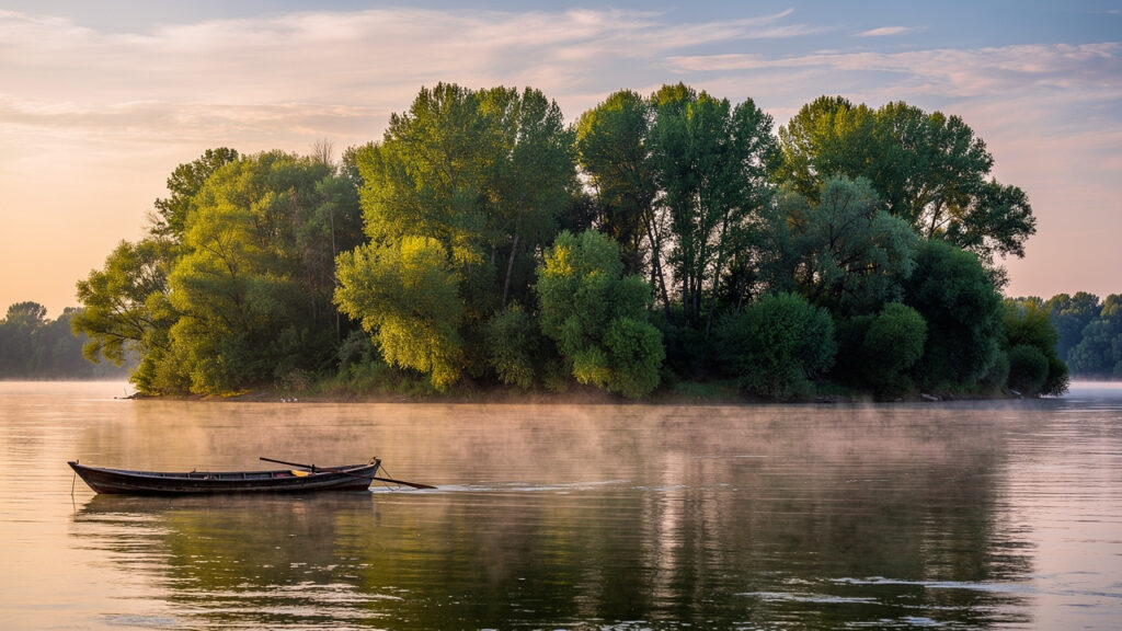
Bulgaria’s Danube islands comprise more than 70 dynamic landforms whose number and area are constantly changing. The largest is Persin, part of a nature park and home to a closed-type prison.
- The number of Danube islands is not fixed and varies between 70 and 120 depending on the season and river level.
- The largest island, Persin, has special access restrictions because Belene Prison is located there.
- Visiting most islands is unregulated and carries risks, including sudden rises in water levels and dense vegetation.
- Many islands, such as Vardim and the Kalimok wetlands, are important bird areas of European significance.
- Economic activity is heavily restricted, with protected areas and forestry operations predominating rather than tourism.
Bulgaria’s Danube islands are living, ever-changing landscapes rather than fixed points on a map. Reaching them is not simply a matter of renting a boat. It requires knowledge of river conditions, land status and, in many cases, special permits. The largest islands are either protected nature parks or subject to special access rules because of their strategic past and present.
These river islands are critically important for biodiversity in Bulgaria and across Europe. As of 2026, they serve as major stopover sites along the Via Pontica migration route for millions of birds. Protecting their wetlands and floodplain forests is an issue of international importance that goes far beyond local tourism.
In practical terms, the islands form a dynamic system governed by water levels. An island that is easy to reach in summer may be completely submerged and dangerous in spring. Planning any visit starts with checking current hydrological conditions, not with a tourist brochure.
| Island | Approximate area (km²) | Status | Accessibility | Key feature |
|---|---|---|---|---|
| Persin (Belene) | ~43 km² | Nature park, prison | Severely restricted; permission required | Largest in Bulgaria; home to Belene Prison |
| Kozloduy | ~6.1 km² | Part of a protected area | Difficult; depends on river levels | Frequently flooded; important for nesting birds |
| Vardim | ~4.9 km² | Protected area | Tourists are not allowed without permission | Ancient floodplain forest unique to Bulgaria |
| Batin | ~4.2 km² | Natura 2000 protected area | Accessible by boat, but access is unregulated | Nesting colony of herons and cormorants |
)
What are the largest Bulgarian Danube islands?
What is the largest Bulgarian island on the Danube?
The largest Bulgarian Danube island is Persin, also known as Belene. It covers around 43 square kilometres and forms the central part of Persina Nature Park. It is also home to the operating Belene Prison.
The largest of Bulgaria’s islands is Persin Island, which is also the fourth-largest island on the Danube as a whole. It forms the core of the nature park of the same name, but much of its territory is inaccessible. The reason is the operating Belene Prison, whose security rules impose strict restrictions on entry. According to official information, the island is surrounded by a group of 10 smaller islands.
The second-largest is Kozloduy Island, located near the nuclear power plant. Unlike Persin, its main challenge is not restricted access but changing conditions. When the Danube rises, large parts of the island are flooded, making visits dangerous and difficult to predict. Other notable islands include Vardim, known for its centuries-old summer oak forest, and Batin, an important refuge for waterbirds.
A serious birdwatching trip here calls for hiring a local guide with a boat. They know not only where the colonies are but also the shifting shallows and currents that do not appear on any map. Trying to reach these areas independently often ends in failure or getting stuck in muddy deposits.
How does the number of islands on the Danube change?
Why isn’t there an exact count of Bulgaria’s Danube islands?
The number varies because the islands are formed from river deposits. The river constantly deposits and erodes sediment, creating new sandbars and small islands or flooding existing ones, especially when water levels change.
The common assumption that Bulgaria has a fixed number of islands is mistaken. They are dynamic geomorphological formations, not permanent landforms. Official sources list around 70–75 larger islands, but the actual number, including the smallest sandbars and temporary deposits, can exceed 120. This process is driven entirely by the river’s hydrology.
When water levels are low in summer and autumn, dozens of small islands and strips of sand emerge. In spring, when the river is high, they may disappear completely. The river constantly redistributes sediment, changing the shape and even the location of smaller islands. Only the largest ones, with rocky foundations or dense vegetation, have relatively stable outlines. Data available as of 2026 indicate that erosion is affecting the banks of some islands because of changes in the river’s water regime.
Approximate total: 70–75 large and medium-sized islands
Main formation process: Accumulation of river deposits (alluvium)
Main factor behind changes: Fluctuations in the Danube’s water level
Critical period: Spring floods submerge dozens of smaller islands
In practice, any map of the islands is only a snapshot in time. Navigating near them, especially in vessels with a deeper draught, requires up-to-date information from the Executive Agency for Exploration and Maintenance of the Danube River, as the shallow areas formed by sediment around the islands are constantly shifting.
)
Status and significance: nature parks and protected areas
Environmental experts view Bulgaria’s islands not as tourist destinations but as a network of key habitats. Many are part of the European Natura 2000 ecological network. They have been designated as protected areas because of their unique floodplain forests and wetlands, which provide habitats for rare and endangered bird species such as the white-tailed eagle, black stork and Dalmatian pelican.
Persina Nature Park is the best-known example. It covers Persin Island and several neighbouring islands, with the aim of protecting the largest area of wetlands along the Bulgarian stretch of the Danube. Visits to the park are strictly regulated and are permitted only with guides from the park’s administration. Other islands, such as Vardim, have the status of a maintained reserve because of their ancient forests, which means that almost all human activity is prohibited.
The Batin Island complex is a specific example of an area with special protection status. It has been designated as a protected area because of its large mixed colony of herons, glossy ibises and cormorants. Any unauthorised approach by boat during the nesting season (April–July) can cause birds to abandon their nests and put an entire generation at risk. This is a common mistake among amateur photographers and tourists who are unfamiliar with local regulations.
Risks and rules for visitors
Is it safe to visit a Danube island by boat?
It can be dangerous. Risks include sudden rises in water levels that can leave you stranded, hidden underwater currents and shallows, and dense, impassable vegetation with no trails.
The most common mistake when trying to visit Bulgaria’s islands is underestimating the river. A sudden rise of a metre or more within a few hours can completely flood the low-lying parts of an island and cut visitors off from their boat. This is a real risk, especially in spring and early summer.
Standard safety practice involves several steps. First, always check both short-term and long-term forecasts for the Danube’s water level. Second, tell someone your route and planned return time. Third, never moor on a low, sandy bank if rising water is expected. Choose high, steep banks and secure your boat firmly.
Main risk: Sudden flooding caused by rising water levels
Navigation hazard: Uncharted shallows and underwater obstacles
Biological hazards: Dense vegetation, ticks and wild animals (wild boar)
Legal restriction: Entering restricted areas without permission
On islands designated as reserves or maintained reserves, such as Vardim, entering without explicit written permission from the relevant Regional Inspectorate of Environment and Water (RIEW) is a legal violation. Even on islands without special protection status, you are entirely responsible for your own safety. These are wild areas with no signs, trails or safety provisions.
Frequently asked questions
Exactly how many Bulgarian islands are there in the Danube?
There is no single, exact figure. The number changes depending on the river’s water level and the counting method used. There are around 70–75 larger, more permanent islands, but the total can exceed 120 if temporary sediment formations and sandbars are included. They continually emerge, disappear or change shape.
What is a ‘sediment island’, and why do these islands appear and disappear?
A sediment island is a landform created by the deposition of sand, silt and other materials carried by the river. These formations appear where the current slows down. They are temporary: strong currents or spring floods can wash them away as quickly as they formed, making them unstable features of the river landscape.
Is Kozloduy Island always accessible to visitors?
No. Access to Kozloduy Island depends heavily on the river’s water level. It is the second-largest Bulgarian Danube island, but it is relatively low-lying. When water levels rise, especially in spring, large parts of the island and sometimes the entire island are flooded. This makes visits unpredictable and potentially dangerous unless hydrological conditions are checked in advance.
Which other islands are part of a nature park besides Persin?
Persina Nature Park includes not only Persin Island but also several smaller neighbouring islands. These are Malki Persin, Shturetsa, Golyama Barzina, Milka and Kitka. Together, this island group forms the core of the protected area, whose purpose is to preserve the wetlands and floodplain forests unique to the Danube region.
What is the difference between an island and a sandbar in a river?
The main difference is stability and vegetation. An island is a relatively stable landform, high enough to avoid flooding every year and supporting permanent vegetation such as grasses, shrubs and trees. A sandbar is a temporary deposit of sand and gravel, usually without vegetation, that emerges when water levels are low and disappears when they rise.