The E8 Route is a trans-European hiking route whose Bulgarian section crosses the Rila and Rhodope Mountains. The hike requires serious physical preparation and offers unparalleled views and an immersive wilderness experience.
- The Bulgarian section of the E8 is approximately 420 kilometers long and connects Musala Peak with the border near Mezek Fortress.
- Budget planning is essential, with accommodation in mountain huts and food costing between €30 and €50 per day.
- One of the main risks is underestimating weather conditions, which can change extremely quickly in the mountains, even in summer.
- Trail markings are unclear or missing in some places, making it necessary to use a GPS device with the route track downloaded in advance.
- The best time to complete the entire route is from late June to mid-September, when snow is less likely to be an issue.
Completing the Bulgarian section of the E8 requires at least three weeks and careful planning, rather than an impulsive decision. It is a serious physical challenge that crosses two of Bulgaria’s highest mountain ranges along a trail that is difficult and poorly marked in places. Success depends entirely on preparation, not luck.
For Bulgarian hikers in 2026, this trek offers a unique opportunity to disconnect from digital noise and immerse themselves in the authentic natural landscapes of the Rila and Rhodope Mountains. The Bulgarian section is approximately 420 kilometers long. It forms part of the European long-distance hiking route network maintained by the European Ramblers Association (ERA).
The idea that this is simply a long walk is fundamentally mistaken. The E8 Route is a test of endurance, navigation skills, and the ability to adapt to rapidly changing conditions, especially in the alpine sections of the Rila Mountains.
What Is the E8 Route and Why Is It More Than a Trail?
Where Does the Entire International E8 Route Begin and End?
The international E8 Route begins in Dublin, Ireland, passes through 10 countries, including the United Kingdom, Germany, and Romania, and ends in Bulgaria, near Svilengrad.
The E8 Route is one of twelve transcontinental hiking corridors designed to connect cultural and natural landmarks throughout Europe. Its purpose is not simply to provide a trail from point A to point B, but to offer an immersive experience of Europe’s diverse landscapes. In Bulgaria, it passes through Rila National Park, as outlined in the park’s management plan, crossing it in a west-to-south direction according to data from the Ministry of Environment and Water.
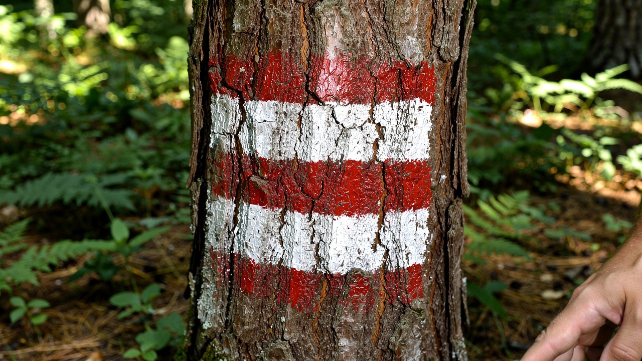
This is not a commercial product, but a network of existing national and regional trails brought together under a common red-white-red marking system. The Bulgarian section is known as the Rila–Rhodope route and is one of the wildest and most scenic routes in all of Southeastern Europe. The trek requires self-sufficiency, as mountain huts are often a full day’s walk apart.
Before setting off, contact the mountain huts along the route to check whether they are open and have available beds. Many of them, especially in the more remote parts of the Rhodope Mountains, operate with limited capacity or accept visitors only by prior reservation.
Key Stages of the Bulgarian Section: From Rila to the Rhodope Mountains
Is the E8 Route Well Marked in Bulgaria?
Trail marking is inconsistent. In popular areas such as Borovets and Yundola, the markings have been renewed, but in remote parts of the Rhodope Mountains they are often faded or missing, making GPS navigation essential.
The Bulgarian section of the E8 Route can broadly be divided into two main parts: the high-mountain section in Rila and the long, hilly section through the Rhodope Mountains. The hike begins in Borovets, climbs toward Musala Peak, passes through Granchar Mountain Hut, and then descends toward the Rhodope Mountains via Avramovo Saddle.
The Rila section is short but technically the most difficult. It covers the first three to four days and includes a crossing of the highest part of the mountain range. Weather conditions here are unpredictable, and the rocky terrain requires good physical fitness. Experts advise against attempting this section before late June because of lingering snowfields.
After crossing Avramovo Saddle, the route enters the Western Rhodope Mountains. Its character changes dramatically, with long hikes through ancient forests, meadows, and small villages. The main challenge here is not elevation gain but the long distances between settlements and mountain huts. Key points along the way include Velingrad, Batak Reservoir, Persenk Mountain Hut, Krastova Gora, and the finish at Mezek Fortress near Svilengrad.
Total distance: Approximately 420 km
Starting point (Bulgaria): Borovets resort
Highest point: Musala Peak (2,925 m)
Endpoint (Bulgaria): Mezek Fortress, near Svilengrad
How Much Does It Cost and How to Prepare for the Hike
Many people assume that mountain hiking is almost free, but a three-week trek such as the E8 requires a substantial budget. Expenses include more than just transport to the starting point and back from the finish. Accommodation and food along the way account for the largest share of the costs.
As of 2026, an overnight stay in most state-run mountain huts costs around €15–€20 per person. Food served at these huts is more expensive because supplies are difficult to transport, so a daily budget of €30–€50 is a realistic estimate. For the entire trek, this amounts to approximately €600–€1,000. Trying to save money on food is a bad idea: insufficient calorie intake leads to rapid exhaustion.
Preparing your equipment is critical. Sturdy hiking boots are essential, and they should be well broken in. New boots are a recipe for blisters and a ruined trek. Your backpack should weigh no more than 15 kg and should contain a rain jacket, a windproof jacket, a headlamp, a first-aid kit, a power bank, and a GPS device or smartphone with offline maps and the route track downloaded in advance.
The Most Common Mistakes and How to Avoid Them
What Are the Main Risks of Hiking the E8 Route?
The main risks include underestimating the weather in Rila, dehydration in the Rhodope Mountains, getting lost because of poor trail markings, and physical exhaustion caused by an overly ambitious daily itinerary.
The biggest mistake is relying solely on trail markings. While they have been renewed along some sections, in others they have been completely erased by time or logging activities. Setting off on the E8 Route without a GPS track is unwise and dangerous.
Another common oversight is carrying too little water, especially in the Rhodope section. In summer, springs along the ridges dry up, and you may have to walk for hours without access to water. The rule is to refill your containers whenever you get the chance. A typical example is the hike between Persenk Mountain Hut and Pashaliytsa Mountain Hut, where water is almost unavailable.
Underestimating the high-mountain section in Rila is the third critical mistake. Even in the height of summer, temperatures on Musala Peak can drop to freezing, and sudden storms are common. The solution is to set off early in the morning and cross the ridge before the afternoon, when the weather usually deteriorates.
What Makes the E8 Experience Unique in 2026?
An experienced hiker approaches the E8 not as a race, but as a journey. Today, the route’s uniqueness lies in the contrast between its wild, almost untouched natural landscapes and encounters with authentic life in the small Rhodope villages that are slowly disappearing. This is an increasingly rare experience.
In recent years, conditions at some key mountain huts along the route have shown signs of improvement, with better accommodation and food on offer. This makes the long trek somewhat more accessible, but does not change its fundamental character as an adventure. The current trend is to use lighter, more technologically advanced clothing and equipment, allowing hikers to move faster and enjoy greater comfort.
Best season: Late June to mid-September
Essential equipment: GPS, compass, first-aid kit, headlamp
Risk of disorientation: High in forested sections
Mobile coverage: Inconsistent, with large areas without signal
The final factor that distinguishes a successful trek is flexibility. Instead of following the plan blindly, you should be ready to change it: spend an extra day at a mountain hut in bad weather or shorten a stage if you feel tired. The E8 Route rewards sensible decisions, not haste.
Frequently Asked Questions
How long does it take to complete the Bulgarian section of the E8 Route?
Completing the entire Bulgarian section, which is approximately 420 km long, usually takes between 20 and 25 days at an average hiking pace. The duration depends heavily on your fitness level, weather conditions, and how many rest days you take. Some experienced hikers finish in fewer than 20 days, but this requires a very demanding daily schedule.
Where does the E8 Route begin in Bulgaria?
The official starting point of the E8 Route in Bulgaria is the Borovets resort. From there, the route climbs into the highest part of the Rila Mountains, passing Musala Peak. Some hikers prefer to start directly from Yastrebets Mountain Hut, which can be reached by lift, to avoid part of the initial ascent.
How can I navigate the E8 trail markings in Bulgaria?
The main trail markings for the E8 in Bulgaria are red. The route follows the main ridges of the Rila and Rhodope Mountains. It is important to know that in many places, the red markings intersect with or run alongside other colors (blue, green, and yellow) that lead to local landmarks. That is why it is essential to have a GPS track for the entire route and not rely solely on visual markers, which can be misleading.
Are there mountain huts and places to stay along the entire route?
Yes, mountain huts and shelters are available along most of the route. In Rila, they are more closely spaced. In the Rhodope Mountains, however, the distances between them increase significantly, sometimes requiring hikes of 8–10 hours. It is advisable to carry a lightweight tent or bivy sack for emergencies, especially in the wilder sections of the Eastern Rhodope Mountains.
What equipment is absolutely essential?
In addition to standard hiking equipment, three items are absolutely essential: a GPS device with the route track downloaded in advance, a reliable power bank to keep it charged, and a complete first-aid kit. Because trail markings are poor and mobile coverage is unavailable in many places, navigation is critical. Reliable hiking boots and a waterproof jacket are also indispensable.
Can the route be completed in separate sections?
Yes, absolutely. Many people choose to complete the E8 Route in separate stages over several weekends or holidays. Convenient access and exit points include Borovets, Avramovo Saddle, Velingrad, Batak Reservoir, and Kardzhali. This is a good option for those who cannot take three consecutive weeks off.